Who Built These Mysterious Concrete Arrows?

arrows
One of the last vestiges of America's early transcontinental airmail beacon system, this concrete arrow still remains, in the desert outside Walnut Creek, CA. Wikimedia Commons (CC By-SA 3.0)

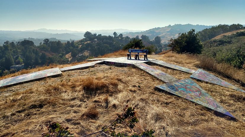
Dotted across the American landscape in rugged, isolated places where tumbleweeds roll, snakes skitter and coyotes howl in the night, huge, mysterious concrete arrows lie like forgotten monuments against a pallet of sagebrush and sand, or on high hills against a backdrop of snow-capped mountains. Are they outcroppings of an ancient underground geometric civilization? Signposts created by aliens to invade Earth? Remnants of the Pony Express – a lost episode that never aired on the History Channel?

Nope, none of the above. But these giant cracked and edge-worn arrows do point toward history: They're the last vestiges of America's early transcontinental airmail beacon system – literally a highway of light – that guided early 1920s airmail pilots, in the days before radar and ground-to-air radio, safely to their destinations as they made night flights from coast to coast.

Advertisement

Nearly a century before satellites, Siri and GPS made ace navigators out of even the most directionally challenged among us, pilots back in the day had to rely on their compass and terrestrial landmarks like mountains, lakes, rivers and railroad tracks to guide the way. Because their open cockpit biplanes had no lights and landing fields weren't illuminated, they could only fly by day, or risk almost certain death.

Consequently, early transcontinental airmail delivery was a hybrid situation that involved leapfrogging the mail around the country by air in the daytime and delivering it to trains that rumbled by night. Using this system, a letter zipping along as fast as possible in 1922 could take up to 83 hours to make it from New York to San Francisco. By 1926, however, when the lighted airway was in place, a letter could be delivered from New York to San Francisco in just 33 hours thanks to the advent of the beacon system. And yet, being a postman of the skies was still a dangerous and potentially deadly job: Of the some 230 men who flew for the Post Office Department (the predecessor of the United States Postal Service) between 1918 and 1927, 32 died in crashes – six in the first week of operation alone.

Advertisement

Ground-based Visual Navigation

In 1924, Congress approved funding for the U.S. Postal Service to build a ground-based visual navigation system. Under the direction of the Postal Service, the Airways Division of the Lighthouse Bureau created beacon stations with concrete arrows. In 1926, oversight passed to the new Aeronautics Branch. Here's how it worked: A series of horizontal 50 to 70-foot (15 to 21-meters) long concrete arrows painted bright chrome yellow were spaced approximately 10 miles (17 kilometers) apart.

At the center of each giant arrow stood a 51-foot (16-meter) steel beacon tower topped with two rotating lights estimated at between 1.25 and 5 million candlepower which, in clear weather, could be seen by pilots for 10 to 40 miles (17 to 64 kilometers). Beneath the rotating lights, two course lights pointed forward and backward along the arrow – flashing a code which identified the beacon's number. Where no electricity was available, a generator shed, located at the tail end of the arrow, fueled the acetylene gas-powered lights. The site number was painted on one side of the shed's roof and the airway on the other side. Each giant yellow arrow pointed to the next giant arrow in a system of sequentially numbered beacon stations that guided pilots safely along their routes.

Advertisement

By 1933, some 1,500 towers and beacons marked about 18,000 miles (29,000 kilometers) of varying routes across the nation. Throughout the 1930s, advanced navigation and radio technologies replaced the visual land-based system and the high cost of operating the arrow and beacon system during the Great Depression finally rendered it outmoded and obsolete – although a handful of beacons continued to operate at minimum capacity into the 1940s. Once the program was defunded, the Department of Commerce decommissioned and deconstructed most of the towers for the badly needed steel that was in short supply during World War II, leaving a cross-country trail of big, lonesome, bright yellow concrete arrows to weather and fade for nearly a century out of context.

Enter the Arrow Hunters

Flash forward to 2018 and meet California retirees Brian and Charlotte Smith, founders and hosts of the website Arrows Across America. Some retired couples buy metal detectors and head for the beach. This intrepid couple grabs their cameras, puts on their hiking boots, buys a Jeep and a drone and hits the highways and byways of America in search of arrows.

Of the some 2,000 arrows that were created for the beacon system, it's estimated that about 200 remain. The Smith's have located and documented a pretty formidable number considering they only started their quest in 2013 and got hooked after Brian hiked to his first discovery in Washoe Co., Nevada. He sent Charlotte pictures from the site because the arthritis in her knees makes it hard for her to climb.

Advertisement

Nevertheless, she persists.

"We have 126 concrete arrow photos on our homepage, two destroyed sites, six metal arrow sites and five other type arrow sites," says Charlotte in an email. "We're finding new sites all the time. When we first started looking, Google maps didn't have clear images for all locations but as they redo areas sometimes an arrow is located. If the site has winter satellite photos it is easier to find the arrow under the trees than in a summer photo. In the East, there is a lot of foliage hiding the arrows and many sites don't have clear ground photos yet. So as better satellite photos are taken we expect to find more arrows. Also, as more people hear about them, they're out looking for them and send us the location when they find one."

The Smiths consider their arrow quest a hobby that they both enjoy – a hobby that allows them to travel the U.S. staying at cool places like the Harley-Davidson room in Winslow, Arizona, stopping in Roswell, New Mexico to learn about aliens, taking photos of arrows at interesting, remote locations and flying their drone.

"We've been on TV, in newspapers and magazines – for 'retired old people' it doesn't get any better than this," says Charlotte. "News reports call people our age elderly, but we sure don't feel elderly! People email, phone, text and post on Facebook new finds to us all the time. A lot of arrow sites have been cleaned, restored and improved upon since we first started. We don't know how much of it was because of us. We like to think that we shed a light that motivated the improvements, but no one has told us that we were their inspiration."

In the past 12 months they've had over 16 million hits to their website – 12 million of those in the last nine months alone. That's a lot of curiosity.

"I think what interests people the most is the same thing that interested us," says Charlotte. "We had never heard about the arrows, we didn't know such things existed and were still out there to be found. We wanted to see one, then another, until we have now personally visited and photographed 94 arrows in 19 states."

Speaking of curiosity, Charlotte wonders if anybody reading this might have any old pictures or documents concerning historic airmail sites, and she believes it's possible some folks do (if so, please visit the Smith's website for contact info – they'd love to hear from you).

"Many of the intermediate landing fields had caretakers and the families lived at the fields. We know there are pictures out there somewhere. Check your old family photo albums. Maybe you are a descendant of someone who helped planes fly across the United States and don't know it!"

Also, Charlotte and Brian have never been in a biplane and would both love to fly over an arrow in one someday.

Advertisement

Advertisement

Loading...