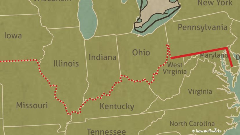
The solid red line represents the Mason-Dixon Line, which was drawn by astronomer Charles Mason, and surveyor Jeremiah Dixon in the 18th century. The dashed line represents an unofficial extension separating free and slave states pre-Civil War. HowStuffWorks
Ask a Southerner where the South begins and you might get answers like "where one-syllable words become two or three" or "where the most honored food are grits and gravy." By those measures, the South should theoretically begin in Richmond, Virginia, or Lexington, Kentucky, or even Wheeling, West Virginia.
But the Mason-Dixon Line, which has been regarded for 200 years as the boundary line between the North and South in the United States, turns that conventional sociological thinking upside down.
Advertisement
That's because the Mason-Dixon Line runs separates Maryland from Pennsylvania and Delaware, which are all considered Northern states. So if the Mason-Dixon Line really is the dividing line between the North and South, why does it put Maryland — the home of the crab cake — in the South?
Todd Babcock, a Pennsylvania surveyor, and founder of The Mason and Dixon Line Preservation Partnership, says Charles Mason (an astronomer) and Jeremiah Dixon (a surveyor) introduced surveying techniques to North America that were used to draw entire boundary lines for western states in the U.S.
"In many respects the techniques we use today are very similar to those used by Mason and Dixon," Babcock says. "I use the analogy that Mason and Dixon used the constellation of stars to guide them and today we use a constellation of satellites."
Advertisement
The Work of Charles Mason and Jeremiah Dixon
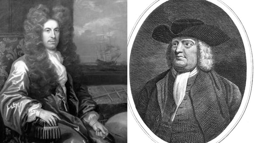
In 1763, the King of England hired Mason and Dixon — who were Englishmen — to settle a land dispute between the aristocratic colonial families, Quaker William Penn II and Charles Calvert (AKA Lord Baltimore III) of Maryland.
Lord Baltimore claimed land that according to the Quakers was rightfully within the Pennsylvania border. The two families quarreled and fought over land for decades. Colonial landowners along the line separating the two proprietors' land feared being asked to pay taxes to both the Penns and Calverts because both families were claiming the same land.
Over 58 months, Mason and Dixon surveyed a 233-mile (374-kilometer) stretch of land, from Philadelphia westward. It was mostly wilderness, and they established the boundaries of Pennsylvania, Maryland, Delaware and western Virginia (now West Virginia). It became a steadfast boundary line, known as the Maryland-Pennsylvania Boundary.
The Penns were to the North with Philadelphia as their hub, and the Calverts to the South with Baltimore as their hub. The Mason-Dixon Line also included the 83-mile (133-kilometer) northern border between Pennsylvania (which is now Delaware) and eastern Maryland. The line starts in the southwest corner of Delaware and runs north.
Advertisement
How Did Mason and Dixon Draw the Line?
Mason and Dixon were hired in 1763 by the King of England to settle a land dispute between the aristocratic colonial families, Charles Calvert of Maryland (left) and Quaker William Penn II. Public Domain
It was meticulous and painstaking work at that time, as the men used the stars as guidance to trace north and arc lines of latitude along the new Maryland-Pennsylvania border. Mason and Dixon — with Iroquois guides leading a traveling party of axmen, wagon drivers and attendants numbering about 120 in the party — cut through virgin forest as they went westward.
The men used an astronomical clock they brought from England to help determine the ellipticity of the Earth. "It added to our understanding of the shape of the Earth and that it wasn't a perfect sphere," Babcock says. "It was bulging in the middle and Mason and Dixon found that while the Earth was indeed round it had undulations."
Advertisement
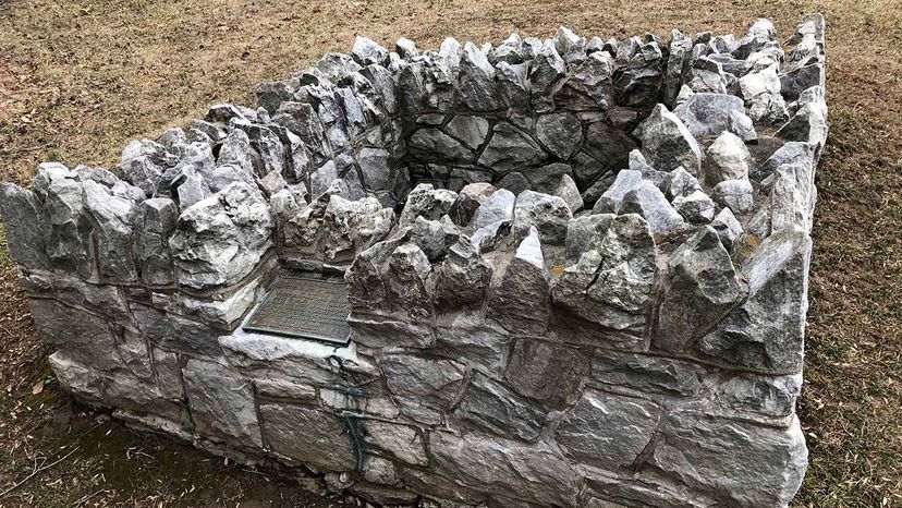
Manmade Markers
Mason and Dixon used this "Stargazer's Stone" near Embreeville, Pennsylvania, as a base point while plotting the Mason-Dixon line. The name comes from the astronomical observations they made there.
Wikimedia/CC BY-SA 4.0
The men also used a zenith sector, "a graduated arc of a vertical circle," which was teamed with a telescope and plumb line. This tripod-mounted surveying tool, known as a Bird Transit (after its inventor, John Bird), was thought lost in history's dustbin, but was discovered by accident in Philadelphia. Now restored, it sits in exhibit in Independence Hall.
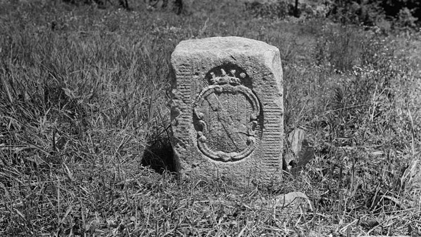
Babcock says the men painstakingly placed limestone posts, also brought from England, at each mile along the way — "crownstones" were set every 5 miles (8 kilometers). These crownstones were carved "C" on the southern side of the rock for Calvert and a "P" carved on the northern side for Penn. Some stones had the Penn coat of arms and others the Calvert coat of arms.
The stones were massive and weighed as much as 500 to 700 pounds (226 to 317 kilograms) each, so when Mason and Dixon and the team got to the Appalachian Mountains, they had to stop placing them around Hancock, Maryland, because they simply weighed too much.
They used wooden posts the rest of the way. They had traveled 132 miles (212 kilometers) from Philadelphia.
Natural Markers
Meanwhile, the border between Pennsylvania and New Jersey was decided by much more conventional means, they simply used the Delaware River as a dividing line, as it skirts east of Philadelphia and makes its way to the Atlantic Ocean.
Additionally, the "twelve mile circle" was constructed as an arc that separates the Delaware and Pennsylvania sides near Delaware Bay.
In 1991, the Mason Dixon Line Preservation Partnership was formed between a group of surveyors from the Maryland side and a group of surveyors from Pennsylvania to conduct an inventory of the original 132 markers. They found all but 10. Floods, the Civil War, farmers cutting fields, and people using them for target practice had left many of the stones damaged or destroyed.
Advertisement
The Dividing Line Between the North and South
So what about this surveying led to the Mason-Dixon Line becoming the unofficial dividing line between where the North ends and the South begins? Blame politics, not Mason and Dixon's line, for the capsized idea of North vs. South.
Limestone posts brought from England were plotted each mile along the Mason-Dixon Line.
Library of Congress
In 1820, Maryland was the northernmost slave state. Pennsylvania abolished slavery. As part of the Missouri Compromise that sought to even out the number of slave states and free states, Maryland was relegated to the "South" because of slavery. The U.S. Congress then declared that territories south of the Mason-Dixon Line were slave states.
Advertisement
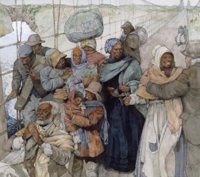
And because the South was holding tight to the idea of slavery, Maryland was the South. Enslaved individuals were free once they stepped into Pennsylvania (at least until the Fugitive Slave Act of 1850). Of course, the Missouri compromise did not last and the country would be embroiled in civil war a few decades later.
So there you have it. The Mason-Dixon Line was a southern boundary and a symbol but, more importantly, it's a lesson on how Mason and Dixon's calculations using the stars have influenced surveyors for more than two centuries.
Now That's a Résumé
The Mason-Dixon Line has been made famous in art and music. The ballad "Sailing to Philadelphia" by musicians Mark Knopfler and James Taylor is one tribute. The Mason-Dixon Line found its way into a "Rocky" movie. It even starred in a Bugs Bunny cartoon.
Advertisement
Cite This!
Please copy/paste the following text to properly cite this HowStuffWorks.com article: